
In reviewing the NVBDR route, I noticed that Butler maps was the key mapping provider for the route. In turn, I stumbled on the Rever app which integrated Butler maps with HERE maps. Development is still ongoing with ver3.0 being released a few days ago. Enhancements are minor, however the big add-on is the introduction of additional mapping partners.
One of the best features Rever offers is the ability for the app to integrate into the website and allow you to plan a ride via the dashboard view. A planned ride can be manually mapped or imported via a GPX file. Once complete, the planned ride will be synced to your phone and allow you to ‘Ride It'.
 |
| Rever Website - Dashboard view |
One minor note: the ‘Planned Rides’ never move to ‘Tracked Rides’ once ridden.
I will definitely be using the website to keep track of my 4wd adventures through the use of the import GPX feature.
I mounted my phone to the KLR650 via the RAM X-Grip and disabled the screen timeout.
The App
The opening screen on the app is the Feed view. By default it displays all public rides. Using the drop down menu will allow you to review your latest rides and those of your friends (that you opt to follow).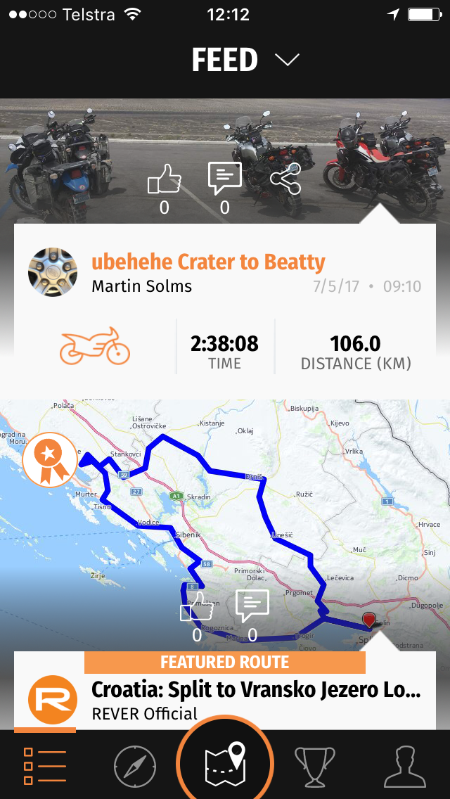
Discover:
The next screen offers you the ability to connect to communities and friends plus find places to ride. The good news is that Rever has partnered with a number of mapping / route providers and now include BDR routes, plus Brazil and New Zealand routes. This section will clearly be enhanced as more partners come onboard.
 |
| Rever App: Discover BDR Routes |
Tracking:
Tracking - it works well. At one point on the Nevada ride, I had the phone in the tank bag and the GPS kept track of the route.

If you opt to ride a planned route, a breadcrumb trail will be overlayed on the map. It does not provide navigation assistance, like Google Maps would, rather it relies on you to navigate.

It was easy enough to follow a planned ride via GPX track (breadcrump) as it overlayed the track on the map. The map screen had a few view options: Centre Map and directional travel.

Profile:
The one minor gripe with the new app is that you need to go to your profile screen, then select rides to view your Tracked and Planned rides. Too many touches to get to that feature.

One interesting feature embedded in the app is the ability to send SMS notifications when a ride is started and finished.
 |
| Rever: SMS Notifications |
Good Points which I loved:
Website planning and overall management of planned and tracked rides.Ability to share planned rides with friends (once they are registered on the website/app). The app has the ability to share your location with friends, although the Premium subscription is needed. The subscription is monthly so I opted to pay for the feature for the Nevada ride and unsubscribe when home.
Features that I think the app needs enhancing:
Waypoints: The ability to navigate to a waypoint or at least show ‘distance-to-go’. Waypoints are not displayed whilst riding. This feature would be useful as it would allow you to easily review how far until that next waypoint, or your end destination. Zoom: Pinch to zoom on my iphone, using gloves does not work. Option for auto-zoom(speed based) or an overlayed Plus / Minus button would work. I like to see perspective when riding (zoom out) but also require detail when the route gets navigationally complex.
Estimated travel time: Probably one of the best features that Tracks4Africa offer is the ability to tell you the average time to travel a track. Tracks4Africa get this right because of the number of GPX uploads and their ability to average the travel time. An awesome feature would be for Rever and the mapping/ride partners to include this capability.
In Summary...
This is the app for you if you enjoy detailed route planning, self navigation and keeping a history of your rides. The app / website integration is the best feature! Don't limit this app to adventure motorcycling - integrate it into your 4x4 overland adventures and build that community!
No comments:
Post a Comment
Comments always welcome...